Malawi is a landlocked country in south-eastern Africa, bordered by Tanzania, Zambia, and Mozambique. Malawi is 118,000km², but one fifth of the country is made up of Lake Malawi, so actual land area is 94,080km², roughly the size of Scotland and Wales combined. The Great Rift Valley runs through the country from north to south, and Lake Malawi lies to the east. Land is made up of mountains, plateaux, hills, valleys, flatlands, and lakeshore. Malawi has a sub-tropical climate, and experiences a rainy season from December to March, a cold dry season from April to August, and a hot dry season from September to November.


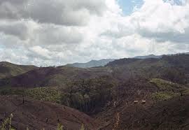
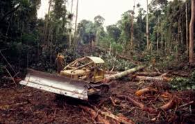
Malawi was previously heavily forested. However, according to the Food and Agriculture Organization of the United Nations (FAO), forest cover is now just 27.2% of the total land area of Malawi. The Northern Region, where RIPPLE Africa is based, has more forested areas than the heavily populated Southern and Central Regions combined.
The challenge for Malawi for the future, with its rapidly growing population, is to help communities to develop a more sustainable approach to the environment.
No comments:
Post a Comment